About a two-and-half-hour drive northwest of Albuquerque is an exquisite archaeological site called Chaco Canyon. It is unfortunate that it is not more well known among the average American because it rivals Machu Pichu for its size and architectural accomplishments. The best estimates place its construction somewhere between 950 and 1150 AD or CE if you want to be politically correct. That is the where and the when, but as for the who, we are not really certain.
I have visited the site twice this year. Once in the winter and once in late spring. I went alone because my family is still in Colombia waiting what seems a lifetime for their visas to be approved. I like taking trips on the weekend because it keeps my mind active. I do not sit around my apartment feeling sorry for myself about how I cannot hold my 18-month-old son and listen to him sing and see him dance with his mother.
The last time I went to Chaco Canyon, I awoke early on a Saturday morning. Not too early. I had planned to get out of bed at 4:30 and then drive to Mesa Verde in Colorado, but I slept in because I drank too much wine the night before. I rose somewhere around 7:00 and was out the door by 8:00. I ate at McDonald’s before heading north on I-25. There are really only two ways to reach Chaco Canyon and going north on I-25 and then turning west on Highway 550 at Bernalillo is the fastest.
It is a wonderful drive. As you leave Albuquerque you wave goodbye to the Sandias on your right with the sun crashing over their serrated crest. The foothills roll out like ripples in the desert and you ride through them crossing through the Sandia Reservation. Just one of many Indian reservations you must pass in order to reach any destination within the state. The foothills are covered in shrub bushes, cercocarpus montanus (I think is its Latin name). Of course, at this time of the year there are also wild flowers, millions of them – white, yellow, purple, and red. Cactuses too, not the big saguaro that you see on Arizona license plates, the prickly pear and the large cane cholla. Higher up on the Sandias you can find Ponderosa pine trees and Aspen trees, but you have to be sufficiently motivated to climb. But today is a day of driving.
New Mexico is vast, and it requires a lot of driving if you want to get anywhere. But the driver is rewarded with unprecedented scenery. To the visible north you encounter the Jemez Mountains, and to the east, Mount Taylor rises in a purple haze like a massive ice berg floating on the desert horizon. To your immediate left is a patch of dense green populated with grasses and Cottonwood trees that line the banks of the Rio Grande whom the Spaniards once called El Rio de Nuestra Señora. I prefer this name because today, like every other day when I drive, I am saying the rosary. This is something I have been doing every day since I was separated from my family. I promised Nuestra Señora that I will pray to her every day until my family arrives, and today I am tracing her river.
It takes about fifteen minutes of driving north before you reach Exit 242 for US-550 West. This is where the drive becomes really spectacular. But first you have to drive through the urban sprawl of Bernalillo, but it doesn’t take too long. You are also passing through the Santa Ana Reservation and then the Jemez and then the Zia and countless others. But what you notice most about crisscrossing through the reservations is how the inhabitants have preserved the land and kept it from being pockmarked with strip malls and other eyesores too often called progress. The land how it was meant to be, natural and hauntingly beautiful.
The first thing you notice as you cross the Rio Grande is a sign indicating the Coronado Historical site on your right. It is the site of an old pueblo along the river that was excavated initially during the New Deal. It was named Coronado because the archaeologists studying the site convinced themselves regardless of evidence that Coronado had wintered there during his time in New Mexico. The second thing you notice is the Santa Ana Casino. It like all the casinos here is always full of cars abandoned by their owners for a time while they search for the American dream amid the smoke and flashing lights of the hundreds of slot machines. However, once you pass the casino you enter a Mars-like landscape where you can settle back with your cruise control set comfortably at 70 miles per hour and watch the scenery unfold.
The road dips and courses through canyon after canyon and continues to rise in elevation. To give you an idea of elevation, Albuquerque sits at about 5,400 feet above sea level. But you gain an 1,600 additional feet as you approach Cuba. This is a small town nearly 7,000 feet in elevation nestled amid pine trees in a picturesque valley surrounded by the Nacimientos Mountains and bisected by the Rio Puerco. It is home to less than 1,000 people, and as I drive through it at a slow 35 miles per hour I notice a number of hippie backpackers emerging from the small hotels. They are all groggy eyed, sunburned, and young – 21st Century Kerouacs – following the rhythm of the road.
Not far outside of Cuba one notices an increase in Ponderosa pines as one climbs up the road as it loops around the mountains’ base before flattening out amid the great expanse of the Jicarilla Apache Reservation. The road passes through this area in silence crossing over the continental divide and the highest point of my trip today of almost 7,300 feet. You descend after this crest until you reach NM-279 West at which point you turn left and leave the smooth as silk US-550 behind you. You have about 4 miles of pavement at which point you leave the comforts of asphalt for a winding dirt and gravel road that cuts through grazing land populated by the occasional sheep and bushy haired cow. Above you the sky is crisscrossed by ravens and sometimes a falcon that swoops down to scoop up a prairie dog.
My car rattles and bumps. The package of water bottles I have in the back of my CRV burst open and scatter across the floor. My teeth chatter, and I abandon the radio all together. There is little to no cell phone coverage much less radio signals that are not interrupted by prolonged bouts of static. Occasionally a farm house rises in the distance and alongside the road you find the bleached white skeletons of cows. Some of them still have patches of black fur clinging to the skulls yet every other morsel has been dried by the sun or eaten by ants and coyotes. You reach a point on this road where you tell yourself, “This is ridiculous. Why am I driving here?” And you don’t even think about the consequences of your car breaking down. However, each day the Park Rangers drive this road two times a day. So, worst case scenario, you are guaranteed to meet at least one government employee at some point if you do break down.
Yet my car powers on at breakneck speeds of 20 miles per hour that is often slowed to 10 miles per hour. The fields to my left and right reach to the horizon in both directions and are green and streaked with wild flowers. The first time I drove this road was in January, and the fields were gray and barren and partly covered in snow. It is now June and the temperature is in the high seventies at this point. Eventually after about 40 minutes of driving, the dirt road ends and becomes asphalt for the final few miles to the Chaco Culture Visitor Center.
Once you enter the visitor center you must pay a fee for your car and an additional fee for each additional passenger. Since these days I am alone I am only required to pay $25. However, the park ranger always asks me how many are in my party. I say one. I don’t like saying this. I’d rather say, “Actually, there are four. But you see, my wife and kids are stuck in Colombia because they don’t have visas.” Although this is a longer conversation, and I have had it on several occasions, it has been my experience that park rangers prefer to talk about the park.
Generally, you need your car once inside the park. It isn’t necessary, but it is a pretty good idea. The park has a road that makes a loop in the canyon that is about 10 miles long. The structures that you can visit are all over the canyon floor, but the road has been constructed along the north and south walls and is bisected by the Chaco Wash, the dry river bed that runs the length of the canyon.
Since it was my second time here. My mission was very specific. The first time I was here was to learn. I was performing preliminary research for an adventure book that I am writing that takes place in New Mexico. But this second trip, I came specifically because I wanted to be able to say how the canyon feels. I was interested exclusively in the energy of the place and letting the rocks and walls speak to me without having to worry that I was seeing every part of the canyon and appreciating its architectural subtleties.
Yet speaking of architectural subtleties raises an interesting point. I mentioned in Part I of this essay the where and the when of the canyon’s construction. But I failed to mention the who. That is who built it. The short answer is the Ancestral Pueblo people. Often you will see them referred to as Anasazi. I do not think this is the right word because it is a Navajo word. Some scholars today are using the Ancestral Pueblo people; however, this presents the same problem because it is an English word. The truth is that we do not know what they called themselves. I do think Ancestral Pueblo people has the best connotation though because it very clearly links the current Pueblo people you find living along the Rio Grande with the people who once lived in Chaco Canyon. Because make no mistake, and the modern Pueblo people will tell you the same, they are the direct descendants of the makers of the Chaco culture.
What though is especially unique about Chaco architecture is its advanced nature that shows both a deep knowledge of building principles and astronomy. Nowhere else in North America north of Mexico will you find such refined knowledge. It is one thing to build a four-story stone structure with mortar, bricks, and wood, but it is something else altogether to align them with the solstices and other points of celestial interests. Compare Chaco to another astronomical site, the Serpent Mound in Ohio. This mound is pointing toward a point where the sun is positioned behind two natural occurring hills during the solstice. It is likely that the builders of this mound noticed this phenomenon and then built the mound in reference to the phenomenon. However, Chaco does not have this type of natural orientation. The builders had to know precisely where the astronomical points were and then build a city on top of them. It is a seemingly subtle difference, but the work and knowledge involved is a profound undertaking.
It seems natural to ask, “Where did the Chaco people learn this skill?” Was it developed right here in Chaco Canyon from nothing but sheer will and determination. Or did it perhaps come from somewhere else? My answer to this is that yes it came from somewhere else. I posit that the Ancestral Pueblo people were Mayan immigrants who came north for various reasons one of which was trade. We know that the Mayan were trading with the inhabitants of Chaco Canyon because archaeologists have unearthed evidence of cocoa or cacao (however you want to spell it) beans and skeletons and feathers of macaws. There are two things we know for certain. At no point in the last several thousand years was this area of New Mexico suitable for raising cacao or supporting a native population of macaws. Macaws were all over this region of New Mexico and were kept as pets or for some other reason. You can see them in the petroglyphs in the Bandolier National Historic Site and find their remains in the Aztec National Historic Site, both of which are farther to the north. Imagine for a moment the act of transporting live and healthy macaws by foot north from Central America to here in New Mexico. I read in Bandolier that the macaws lived three to four years in captivity in New Mexico. How anyone came up with this number is, to me, absurdity at its finest. Macaws routinely live 75 years in captivity today. And whoever made this claim is willing to tell me that the same group of people who learned to domesticate macaws and raise and successfully transport them thousands of miles did not know how to successfully care for them once they arrived in New Mexico. Such an assumption seems pretentious to me at best.
Naturally, one’s next question might be “Which Mayas?” That is, the Mayas were spread across various parts of Central America, so do you have an idea of which part of Central America the Ancestral Pueblo people, assuming that they were Mayan immigrants, came from. I posit they came from Palenque. I say this for three primary reasons: first, Palenque is old and possibly the mother culture for Mayan civilization; second, one finds macaws in the part of Mexico where Palenque is located; and third, the T-shaped door. One finds throughout Palenque a unique architectural feature; that is, a T-shaped door. I am not sure why, but I posit that it is an unusual way to make a door. A T-shaped door is exactly as it sounds. Imagine a doorway like any other doorway except at the top you have two arms cut out to form a T or a Greek Tau. I offer no conclusions as to why this is, but I posit that it is not the natural way one would make a door. In fact, it makes the process of making a door much more difficult.
Now, where you find the T-shaped door in Chaco Canyon is especially interesting. Keep in mind that only a fraction of Chaco Canyon has been excavated. The vast majority of the buildings lie beneath the desert sand. But if you drive to one part of the site called Casa Rinconada you will find the reconstruction of a great kiva. Exactly what is a kiva deserves its own blog posting, so I will not go into that at the moment. But keep in mind two things. First, the kiva is a place of religious significance. It is built partly below ground and partly above ground. Second, the great kiva in Chaco Canyon is massive. If you were to make the comparison of a kiva to a cathedral (which is probably very tempting yet dangerous intellectual exercise though I will do it for this one analogy). A normal kiva would be your local parish church, but the great kiva is something along the lines of Saint Peter’s in Rome. Without going into more detail, you find this architectural phenomenon on this great kiva, but not on the other kivas. Yet bear in mind this architectural detail because I will return to it in later posts.
As I said though, my purpose in this trip to Chaco Canyon was to experience the energy of the place. About a mile or so into the park I stopped at the parking lot between Pueblo Bonito and Chetro Ketl. I then walked around Chetro Ketl. The thing that really stands out for me at this site is the sound the ground makes as you walk. It has that nice crunch-crunch sound you get from walking on gravel, but here and perhaps it is because you are trapped inside the canyon, it seems more pronounced and internal like you are eating cereal before the milk has softened it too much. The wildflowers were everywhere and growing in dirt and places that one would never imagine a flower to grow. White flowers, yellow flowers, and purple flowers. There were of course more, but these caught my eye the most.
I walked behind the great buildings of Chetro Ketl and then over to Pueblo Bonito, the real center piece of the park. It is massive and in many ways beyond words. In its original state it was four stories or higher, had massive courtyards, a great many kivas, thousands of rooms, etc. It honestly rivals and arguably surpasses the buildings you find in Machu Pichu. I was very much enjoying myself, but the one thing I noticed is that the site was definitely more crowded than it was in January. It is nothing like Bandolier where you have to be bussed into the site, and several thousand people will arrive daily. But it is markedly different with many people around you. I have no real issue with other people in general with the exception of one thing. Many are profoundly disrespectful. I do not mean vandalizing or stealing things; although, this happens too. I reference the mere act of talking. How many times in our daily lives do we get to come across and face to face with the sacred? Not often, if you are like me, and labor inside a windowless room with a dozen other attorneys writing decisions and memoranda that no one will ever read. So, when you encounter something like Chaco Canyon why do so many people feel the need to fill the silence of the canyon with such inane chatter.
With this need of quiet in mind, I left the groups of people and went off-road. There are certain sections of the park that require a permit to hike. The first time I saw this, I was deterred from going, but upon closer inspection during this visit I realized a permit was given by simply filling out a card with your name, personal information like address and phone number, and the time at which you began your hike that is then deposited in a wooden box. The idea being that the park rangers can find you, in theory, later if you go missing. Next to the wooden box was a warning about mountain lions. This is a fairly common sign on some hikes, but I did not see a mountain lion on this day.
The odd thing about this hike though is how you actually get to the top of the canyon. If you look at the north side of the canyon where you find Pueblo Bonito you will notice that it is a sheer rock face that races up a few hundred feet. However, if you keep walking along the canyon floor you will see that one section of rock has separated from the rock face thus providing a natural stairway to the top. I use stairway very loosely here because it is a tricky hike that requires you to shimmy over boulders and perform several switch backs before disappearing behind a massive breakaway sheet of rock that split at just such an angle that it allows you to walk up to the top of the canyon. Once you reach the top, the walk is fairly simple and not overly difficult assuming you have no great fear of heights or mountain lions.
The upper rim of the canyon afforded me the serenity and isolation for which I was desperately searching at the bottom of the canyon. I hiked back to Pueblo Bonito for about a mile and was rewarded with a panoptic view that gave me an appreciation of the site that was inconceivable at the bottom.
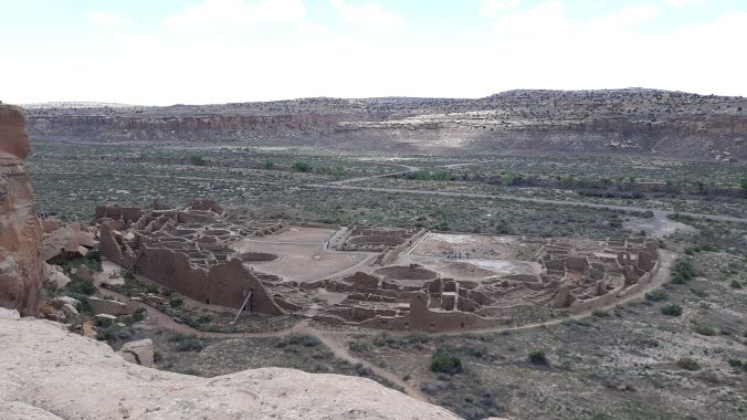
The above is a photo I took from the top of the canyon. I do not wish to comment on the architecture at this point, but one thing in particular struck me that I had not noticed before. That is, I immediately remembered the layout of the Poverty Point Site in Louisiana. Compare for yourself with a photo I took from the National Park Service website.

The half circle shape is similar, and I would suggest a little unusual. However, I think perhaps at one time there was another similar structure in Chaco Canyon that mirrored Pueblo Bonito across the Chaco Wash. You can also see mirror sites at another UNESCO site in New Mexico – the Taos Pueblo, which I will discuss in a future post.
After a few hours of climbing and walking I decided to return to my car, which I discovered was much farther away than I had imagined. I had ambitions of spending more time at the site, but by the time I reached my car I was exhausted. I see some people hike all day and run around with those backpacks equipped with a tube to hydrate better. I am not cut from this cloth or perhaps I am getting too old, but I decided to drive home instead. The road out is always a little easier than the road in. I stopped at the gas station on US-550 that you first encounter when entering the park, and I bought peanut M&Ms and a Gatorade (my lunch) before driving back to Albuquerque.
The drive is of course as spectacular entering Albuquerque as it is leaving Albuquerque. But there is one thing that really draws your attention. The Sandia Mountains. They reach a top elevation of about 10,600 feet, but when you are in Albuquerque you never really get to appreciate how big they are because you are literally in their foothills. Yet when you drive back on US-550 you see them emerge in the distance. Initially they are a hazy purple just floating in the distance, but as you get closer they become a giant island of granite covered in every shade imaginable of green and pink.

